
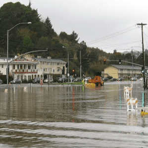
As county and regional agencies gathered feedback from their respective communities about the best paths forward to address sea-level rise in recent weeks, the answer those agencies received from southern Marin residents was clear, as attendees lined up at a public forum Thursday at the Tamalpais Valley Community Center to express concern that Marin City’s inadequate drainage system, and overall infrastructure, cannot support such a project, according to the Marin Independent Journal.
The project focuses on about a mile of Highway 1 and Highway 101 around Marin City. The area has experienced notorious flooding, and Caltrans officials are exploring the idea of raising the highway 10 to 14 feet, moving a nearby commuter lot and adding a bike path.
Caltrans project manager Daniel Cuellar insisted that while the project is eligible for state funding, funds have not been secured yet, and the project is in the beginning of the planning process and is mostly conceptual.
Three ideas, based on guidelines laid out by the California Ocean Protection Council, include elevating the multiuse path on a levy and wall system, raising both roads and the parking lot, or realigning Highway 1 to above Highway 101, according to Cuellar.
“These are still very early concepts at this point though, and that kind of subject would be studied more in the environmental stage,” Caltrans spokesperson Matt O’Donnell said. “Since this is an early engagement period, Caltrans wanted to receive as many ideas from the public as possible.”
Damian Morgan of Marin City Climate Resilience said the community has been experiencing severe flooding for decades. He said the highway slants toward Marin City, bringing more flooding and polluted runoff to the area.
“The people know this issue,” Morgan said. “It’s not a new issue. It’s an old issue and it’s been ignored.”
Residents at the meeting were concerned the project would exacerbate these issues. Flooding in Marin City, either tidal or from stormwater, is compounded by a deteriorating drainage system.
In a previous meeting in February, residents spoke at length against the idea of moving the Manzanita commuter lot to the Gateway Shopping Center in Marin City.
“To bring these massive buses and hundreds of more cars, you know 50, 60, 70 buses a day, is going to bring pollution,” Morgan said. “It would overload our community in more ways than one.”
Cuellar said in response that Caltrans is no longer exploring that area as an option based on the community comments. Still, many residents of Marin City worry about the effect a bike path — to accommodate 600,000 cyclists a year — might have.
“We don’t need county people and all these different agencies,” Farmer said. “We need to have Marin City people as part of the stakeholders also, because you’re talking about community engagement. So how can you have community engagement if you’re not really engaging in the community? But we’ve got to be invited to the table.”
County Unveils Marin County Sea Level Rise Vulnerability Dashboard
A new online tool created by Marin County’s public health office aims to chart the risks various areas face from the rising sea level, according to the Marin Independent Journal.
The “vulnerability” dashboard uses social factors as well as geographic ones as the basis for its determinations. The map identifies areas in Novato, Marin City, San Rafael, Mill Valley, Kentfield and Larkspur as most socially vulnerable and with the highest flood risk.
The dashboard is meant to be a community planning tool, said Dr. Matthew Willis, the county’s public health officer. He said that historically, flood risk has been measured by physical factors such as infrastructure, elevation and water flow.
“I think our tool, our goal, was to contribute to that conversation and to add important context to more dimensions around vulnerability,” Willis said. “But from a human health standpoint, any disaster, whether it’s a heat wave or a flood, the people who tend to suffer the worst consequences are people who have social vulnerability.”
Factors that make a community vulnerable include the rates of medical conditions and social isolation, especially for seniors. Additionally, deteriorating housing and infrastructure can make evacuation harder or might not survive climate-related events.
Lastly, social barriers — financial, cultural, lingual — can increase vulnerability by limiting access to transportation, information, health care, social services, and food.
READ THE MARIN IJ’S FULL STORY HERE.
