‘Save Those Behind You’: Armed with Google-Powered Data & Simulations, City of Mill Valley Eyes Innovative, Multi-Faceted Evacuation Plan in the Event of a Wildfire

In the aftermath of the 2017 Tubbs Fire, which destroyed Southern Marin Fire District Deputy Chief Tom Welch’s home in Santa Rosa’s Coffey Park neighborhood, the possibility of developing a data-driven evacuation plan that innovated beyond the significant constraint of having only two main arteries, East Blithedale and Miller avenues, gnawed at Vice Mayor John McCauley.
In a longshot effort, he reached out to an ex-colleague at his former accounting firm – she’s now at Google – in the hopes of leveraging some of the brightest minds in the world.
McCauley says he’s been a “gentle pest” in the years since and got connected to the Google Research group, whose members agreed to build a simulation – a “massive model” – of the City of Mill Valley’s 6,000 households and those in its surrounding unincorporated areas, “down to the street level, making some assumptions about how cars leave in an evacuation,” he said.
For comparative purposes, they also did so for the Town of Paradise, where the Camp Fire in 2018 killed 86 people, displaced tens of thousands of people and destroyed nearly 19,000 buildings. It was the deadliest and most destructive fire in California history.
The study, which was developed into an academic paper titled “Simulation pipeline for traffic evacuation in urban areas and emergency traffic management policy improvements through case studies,” appeared in the Transportation Research Interdisciplinary Perspectives, a peer reviewed global technical journal.
At the March 15th City Council meeting, City officials said the findings confirmed some existing strategies and highlighted some new opportunities to get residents to safety quickly. Some of them are common sense, they said, like the need for families to evacuate in a single car to avoid clogging roads, thus cutting evacuation times by one hour. “Taking a single car makes a huge difference in our ability to get everybody out of town,” McCauley said. “Save those behind you!”
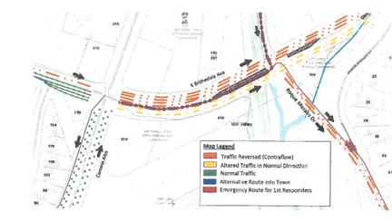 A diagram of “contraflow” on East Blithedale in an evacuation.
City officials have also invested in signage and infrastructure to be able to quickly communicate those changes in the event of an emergency, they said. On Miller, that strategy fits within the framework of the parking restrictions that require curbside parking to be vacated in the event of a Red Flag warning to increase outbound capacity.
The biggest new takeaway is a possible strategy to turn a number of large facilities – Bayfront Park, Friends Field, Tam High and the Safeway and Whole Food Market parking lots, among others – into intermittent, temporary parking lots as a way to unclog Miller and Blithedale.
“It’s critical to get cars up in the canyon down to the valley floor,’ McCauley said, noting that the stretch of Blithedale from downtown to Camino Alto is approximately 6,000 feet long. “How do we make those cars go away?”
Bayfront, located at the Sycamore Ave. dead-end at the multi-use path, could hold approximately 2,000 cars, with at least another 1,500 cars at Tam, McCauley noted.
City officials plan to hold an evacuation drill later this year to test out these strategies. “This will not be the end of our adjustments on vehicle routing – it’s just the beginning,” MVPD Lt. Lindsay Haynes said.
The concept builds on the years-long work of local first responders that they needed to create interim, local safe havens for evacuees, since Mill Valley’s main arteries, and the larger roads they lead to, will likely get overwhelmingly clogged quickly.
Welch has championed the concept of Community Refuse Areas – safe heavens like the Mill Valley Golf Course, Mill Valley School District facilities and sports fields, for instance – within the community that are “designed to provide a greater level of survivability than shelter-in-place. Those areas are deemed safe because they are full of open green spaces that are non-combustible,” Welch said.
Mill Valley has long been at the forefront of disaster planning, from all of the above to the ongoing deployment of LRAD sirens – Long Range Acoustical Devices – that look like big loudspeakers and are considerably more powerful and more efficient than the sirens the city previously used, as well as the Hi-Lo Siren.
“We in Marin are so far ahead of almost any other county in the state as far as the cohesion of our fire agencies, the way that our fire and law enforcement agencies work together,” Mayor Sashi McEntee said. “We have a really robust community wildfire protection plan that has parcel-level mapping of fuels, including very detailed information about what the likely source of embers is going to be. We are in such a incredibly strong place.”
McCauley celebrated the City’s progress but called for continued vigilance and innovation. He cited a famous quote by boxer Mike Tyson: “Everyone has a plan until they punched in the mouth.”